Home Multi-Country Search About Admin Login
Cenozoic
Cretaceous
Jurassic
Triassic
Permian
Carboniferous
Devonian
Early Paleozoic

Search by
Select Region(s) to search
Hold Ctrl (Windows/Linux) or Command (Mac) to select multiple
Surin Formation
Click to display on map of the Ancient World at:
Surin Fm base reconstruction

Surin Fm


Period: 
Neogene

Age Interval: 
Middle Miocene (2)


Province: 
Andaman Sea: Mergui Basin

Type Locality and Naming

At the interval from 1,760 feet to 2,420 feet in the Payang well; named after Surin island (Polachan, 1988). Parent unit: Mergui Gr.

Synonym: หมวดหินสุรินทร

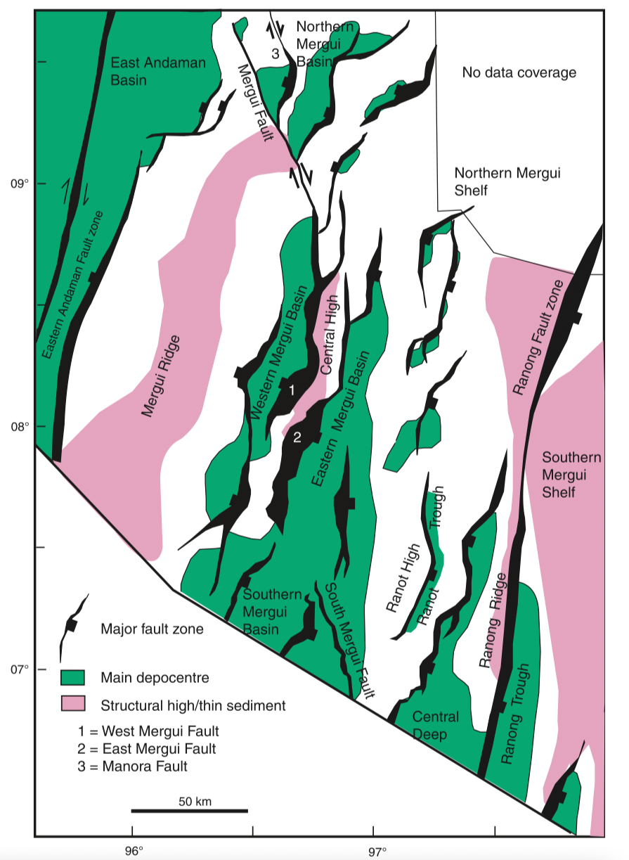
[Figure 1: Map of the Mergui Basin showing the main structural features including basin depocentres, based on an extensive grid of 2D seismic reflection data. (From C K Morley & A Racey, 2011)]


Lithology and Thickness

Mainly sandstones interbedded with shale and limestones; abundant foraminifera, gastropod and bivalve fragments. Thickness: 198 m.

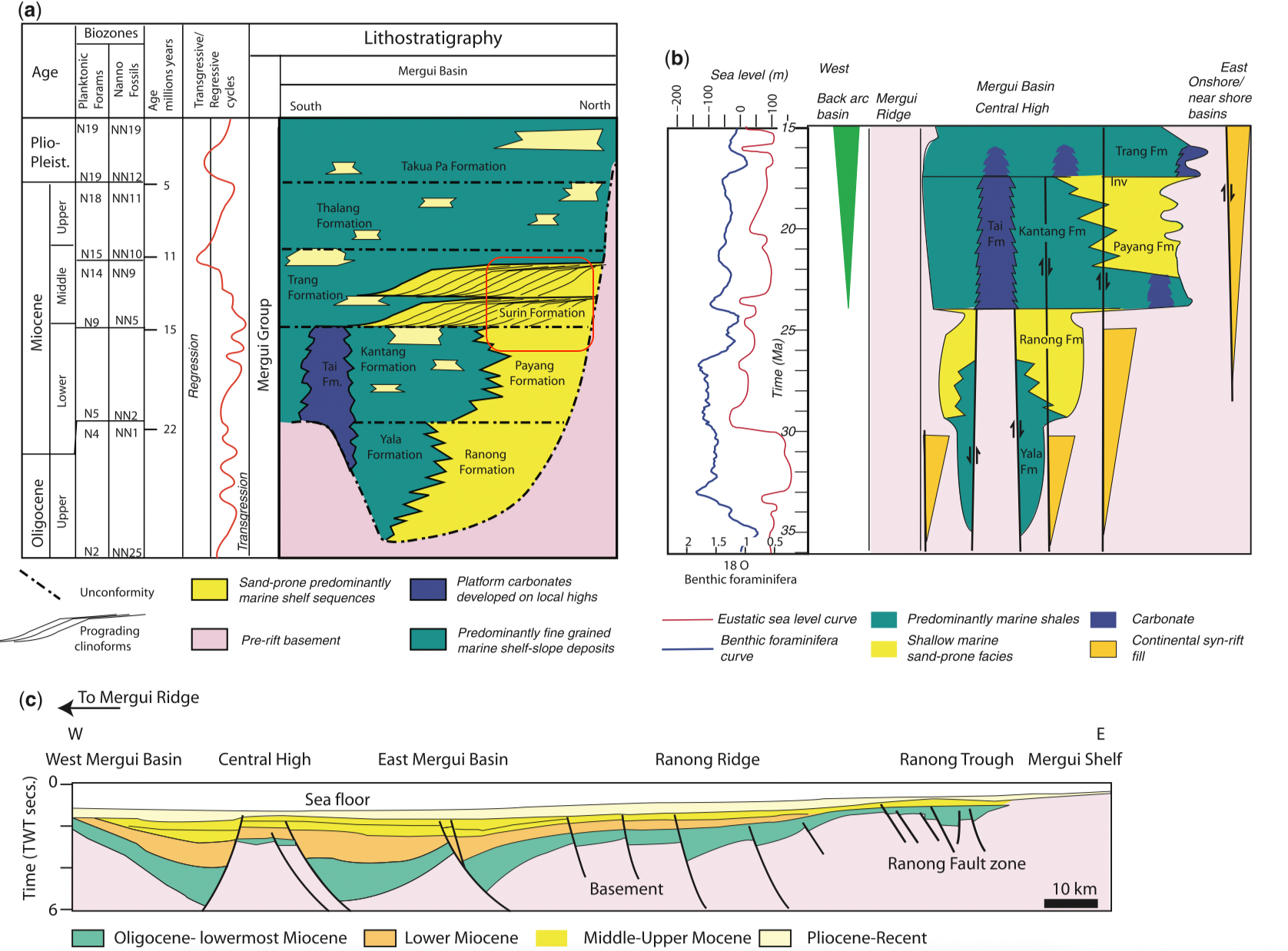
[Figure 2: Stratigraphy and cross-section through the Mergui Basin, Andaman Sea, based on data in Polachan & Racey (1994) and Andreason et al. (1997). (a) Oligocene–Recent stratigraphy of the Mergui Basin; (b) stratigraphy of the syn-rift section (Oligocene–early Miocene) schematically illustrating the east–west variation in stratigraphy across the basin and the effect of rift-basin highs (e.g. Central High horst block) on large-scale distribution of sedimentary facies, modified from Andreason et al. (1997); (c) east–west cross-section through the Mergui Basin illustrating the typical half-graben geometries of the basin (modified from Polachan & Racey 1994). (From C K Morley & A Racey, 2011)]


Lithology Pattern: 
Sandstone


Relationships and Distribution

Lower contact

Payang Fm (unconformable)

Upper contact

Trang Fm (Conformable)

Regional extent

Andaman Sea: Mergui Basin (north part)。 Correlation: Baong Fm of North Sumatra Basin.


GeoJSON

{"type":"Feature","geometry":{"type":"MultiPolygon","coordinates":[[[[96.42,9.64],[96.37,9.79],[96.39,9.91],[96.5,10.01],[96.69,10.1],[96.92,10.14],[97.23,9.93],[97.31,9.81],[97.31,9.64],[97.27,9.47],[97.26,9.34],[97.21,9.16],[97.13,8.98],[96.96,8.94],[96.85,8.9],[96.76,8.89],[96.66,9.08],[96.56,9.32],[96.42,9.64]]]]}}

Fossils


Age 

Middle Miocene For graphic purposes, put here as lower-Middle Miocene, with Trang Fm above.

Age Span: 

    Beginning stage: 
Langhian

    Fraction up in beginning stage: 
0.0

    Beginning date (Ma): 
15.99

    Ending stage: 
Serravallian

    Fraction up in the ending stage: 
0.0

    Ending date (Ma):  
13.82

Depositional setting

Shallow marine environment


Depositional pattern:  


Additional Information


Compiler:  

Wen Du - modified from- C. K. Morley & A. Racey, 2011, Chapter 10 Tertiary in Ridd, M.F., Barber, A.J., and Grow, M.J., editors, The Geology of Thailand, Geol. Soc. of London.;Lexicon of Stratigraphic Names of Thailand of 2013.